 |


| |
|
| |
|
 |
| |
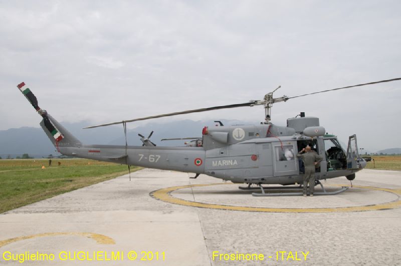
Elicottero Marina
Militare | |
Italian
Navy helicopter |
 |
| AB
212 ASW - 7-67 - MM81377 | ||||
| Bandiera | Flag | Italiana - Italian | |||||||
| Corpo di appartenenza | Group membership | Marina Militare Italiana - Italian Navy | |||||||
| Costruito | Built | ||||||||
| Numero di costruzione | Construction number | ||||||||
| In servizio | In service | ||||||||
| Costruttore | Builder | Agusta | |||||||
| Materiale della carlinga | Nacelle's material | ||||||||
| Compartimento Aereo | Home Port | Napoli - ITALY | |||||||
| Matricola | Matriculation | MM 81377 | |||||||
| Nominativo Internazionale | Call Sign | ||||||||
| Lunghezza Max | L.o.a. | 14,02 m | |||||||
| Apertura alare max | Wingspan max | 14,49 m | |||||||
| Altezza | Depth | 4,53 m | |||||||
| Peso max al decollo | Maximum take-off weight | 5.080 kg | |||||||
| Motore principale | Main Engine | 2 - Pratt & Whitney PT-6T-3 | |||||||
| Potenza Motori | Engine Power | ||||||||
| Eliche di propulsione | Propellers | ||||||||
| Velocità massima | Max speed | 130 kn | |||||||
| Tangente | Tangency | 15.000 ft | |||||||
| Distanza di atterraggio | Landing distance | ||||||||
| Equipaggio | Crew | 2 - piloti/pilots + 2 operatori/operators | |||||||
| Autonomia | Range | 360 nm | |||||||
| Apparecchiature elettroniche | Electronic equipments | 1
- radar APS-705 (V 32 ) 1 - dipping sonar AQS 13 | |||||||
| Armamento | Arms | siluri Mk 46 | |||||||
| Inserita | Posted |
19.02.2012 | |||||||
| Aggiornata
al | Last
updated | 19.02.2012 | |||||||
| INFORMAZIONI
STORICHE L'autonomia dell'AB-212, in base al carico ed alla configurazione dell'elicottero, può variare tra le due e le tre ore di volo. L'AB-212 è dotato di un verricello di soccorso, per attività di recupero naufrago (oltre che di rilascio/recupero operatori in zone impervie) e di un gancio baricentrico utile per il trasporto di carichi sospesi. L'elicottero è dotato di galleggianti autogonfiabili assicurati ai pattini, azionabili in caso di ammaraggio forzato, e di appositi travetti per l'aggancio di particolare armamento o dei serbatoi supplementari da 425 litri. Negli ultimi anni è stato sottoposto ad importanti aggiornamenti quali la sostituzione dei vecchi apparati radio con un nuovo sistema multi banda V/UHF (SRT 651), in grado di coprire anche le bande di frequenza "Marine", e l'installazione di un nuovo radar doppler NAV.SYS. (ANV-301 DGNS) per la navigazione.E' dotato di un radar di ricerca APS-705 (V 32 ) Track While Scan, in grado di stabilire la rotta e la velocità del bersaglio in automatico oltre a fornirne la posizione in termini di coordinate o di rilevamento/distanza.L'avionica comprende il sistema AATH-547A, un sistema di avvicinamento automatico all'hovering su mare, per il successivo impiego del Sonar (Sound Navigation and Ranging) AQS-13 (che può essere immerso fino a una profondità di 140 m).Un importante passo in avanti è stato fatto grazie all'introduzione del sistema Flir Star Safire II installato sotto il "Muso" dell'elicottero e che può essere integrato dall'Lrf (Laser Range Finder) geo-referenziato. Il Flir è in grado di generare immagini utili per l'identificazione di una nave già a 25 miglia di distanza, operazione che in passato veniva effettuata otticamente e solo a distanze ravvicinate. HISTORICAL INFO The autonomy of the AB-212, according to the load and the configuration of the helicopter, can vary between two and three hours of flight. The AB-212 is equipped with a winch for rescue, for recovery activity castaway (as well as release / recovery operators in inaccessible areas) and a barycentric hook useful for the transport of a suspended load. The helicopter is equipped with inflatable floats secured to the brake pads, operable in the event of ditching, joists and appropriate for the attachment of particular equipment or of the additional tanks from 425 liters. In recent years has been subjected to important updates such as the replacement of the old radio equipment with a new multi band V / UHF (SRT 651), able to cover also the frequency bands "Marine", and the installation of a new doppler radar NAV.SYS. (ANV-301 DGNS) for the navigazione.E 'equipped with a search radar APS-705 (V 32) Track While Scan, able to establish the route and speed of the target automatic addition to furnish the position in terms of or coordinates detection / distanza.L 'includes the avionics system AATH-547A, a system of automatic approach all'hovering on sea, for the subsequent use of the Sonar (Sound Navigation and Ranging) AQS-13 (which can be immersed up to a depth of 140 m). an important step forward was made with the introduction of the FLIR Star Safire II system installed under the "muzzle" of the helicopter and can be integrated dall'Lrf (Laser Range Finder) geo-referenced . The FLIR is capable of generating images useful for the identification of a ship already at 25 miles away, an operation which in the past was performed optically, and only at distances close
| |||||||||